Consider a sensor network composed of satellites and UAVs, similar to the one from Problem 2 but for the purpose of Earth observation instead of communications.The system receives a list of imaging tasks. Each task is characterized by a latitude, longitude, and priority. Each sensor in the network can only do a subset of the tasks, depending on the required sensor capabilities Moreover, even between the sensors that can do the task, the value of each sensor performing each task differs due to the specific sensor characteristics and the state (e.g., position) of the sensor at a given time. Similarly, the cost of doing the task is different for the different sensors. At a given point in time, the value and cost of each agent performing each task are provided in the tables below.
1. Given Q_ij and C_ij below and ignoring any other aspects of the problem, formulate an optimization problem to find the assignment of tasks to platforms that maximizes V=Q - C. What kind of problem is it? 2.Solve the problem (you can use Matlab or Python's optimization libraries)
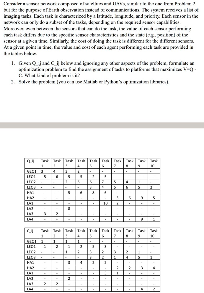
Q_ij
Task Task Task Task Task Task Task Task Task Task 1 2 3 4 5 6 7 8 6 10 GEO1 3 4 3 2 . - - - LEO1 5 6 5 5 2 5 . . LEO2 - 2 6 6 7 5 4 1 LEO3 3 4 5 6 5 2 HA1 . 5 6 8 6 - - - HA2 - 3 9 9 5 LA1 - - - - 10 2 - - . LA2 8 - - - - - LA3 3 2 - - LA4 - . - - - 9 1
C_ij
Task Task Task Task Task Task Task Task Task Task 1 2 3 4 5 6 7 8 9 10 GEO1 1 1 1 1 . . LEO1 1 2 1 2 5 3 LEO2 1 2 3 2 3 2 1 LEO3 3 2 1 4 5 1 HA1 - 3 4 2 2 . HA2 - - - - - 2 2 3 4 LA1 - - 3 1 - LA2 2 LA3 2 2 - - - . - - - LA4 - . - . - - - 4 2